Subscribe to RSS
December 31, 2019
What the History of Isewan Typhoon Teaches Us
Typhoon Vera of 1959, or the Isewan (Ise Bay) Typhoon as it is known in Japan, is without doubt one of the most catastrophic natural disasters the country has ever experienced, with more than 5,000 deaths to its name. It led to the enactment of the Basic Act on Disaster Management two years later and prompted the establishment of the Departments of Civil Engineering and Architecture at Nagoya University's School of Engineering. In 2019, Meidai's Disaster Mitigation Research Center played the central role in organizing a series of events to mark the 60th anniversary of the disaster, ranging from a special exhibition and symposia to a field excursion tour visiting places associated with the Isewan Typhoon. These events brought different aspects of the disaster into sharp focus and, given the recent warnings about the possibility of a "Super Isewan Typhoon" hitting our shores, it is clear that we cannot brush this disaster aside as a mere episode from the past.
We need to do more than just to keep the memory of the Isewan Typhoon alive in the areas that experienced its might; it must be shared widely beyond the affected areas - after all, it is just as possible that we may be hit by a "Super Tokyo Bay Typhoon" or a "Super Osaka Bay Typhoon." Sadly, there seems to be very little interest in the issue in other regions at present. We must share the experience and make the most of it across Japan and around the world, and Meidai has a big role to play in making this happen.
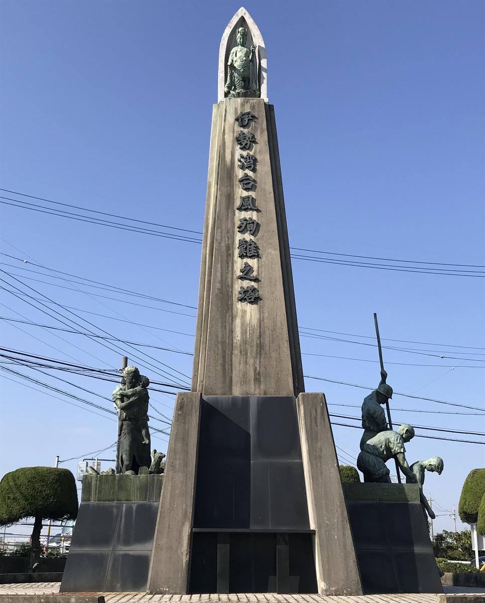
 The storm surge breached numerous banks along the lower reaches of the Kiso Three Rivers, and it took 53 days to close off the rivers. The Ise Bay Typhoon Memorial, built on the final site of the closing of broken dikes, was one of the tour stops (Kuwana,
Every catastrophic disaster has a "face" - a distinctive feature that is forever etched in our collective memory. The unforgettable face of the Isewan Typhoon's was its ferocious storm surge. It washed away giant logs stored in the timber basin at the port and knocked buildings down with them. It destroyed coastal defenses and riverbanks and inundated a wide area; some places remained under water for more than four months. After the disaster, it was decided that the height of new dikes would be based on the height of this storm surge.
Typhoon Hagibis - "Number 19" under the Japanese typhoon numbering system - that hit Japan in the autumn of 2019 submerged a bullet train yard under the floodwater from the Chikuma River, but the Chikuma was not alone; a record number of rivers flooded across a wide area of the Kanto and Tohoku regions, causing extensive damage. In Japan, only typhoons that have caused significant damage are given a special name retrospectively, which must happen by May of the following year. Number 19 looks set to become the first named typhoon in 42 years, the last one being the Okinoerabu Typhoon (Typhoon Babe) of 1977. The Isewan Typhoon was closely preceded and followed by other named typhoons, including the Toyamaru Typhoon (Marie) in 1954 and the Kanogawa (Ida) and Miyakojima (Sarah) Typhoons in 1958. In recent years, typhoons have become larger and stronger. In terms of storm area size, Number 19 was as big as the Isewan Typhoon, and with typhoons of this scale becoming increasingly common, we may see another cluster of named typhoons hitting us. It is predicted that climate change will make typhoons more violent; it would not be a surprise if we start seeing the arrival of named typhoons prefixed with the word "Super" soon.
The Disaster Mitigation Research Center crowdfunded the events marking the 60th anniversary of the Isewan Typhoon with the slogan "It's Coming! - To Be Ready for a Super Isewan Typhoon" and raised around 2.5 million yen in three months, far exceeding the target of 2 million yen. Among the various events held as part of this initiative was a unique field excursion tour, organized as a thank-you gift for donors, to visit areas affected by the storm surge and flooding and facilities associated with the disaster. According to Takashi Tashiro, Designated Professor specializing in river engineering and Deputy Director of the Disaster Mitigation Research Center, the purpose of the tour was to take a fresh look at the Isewan Typhoon 60 years on from the frontline.
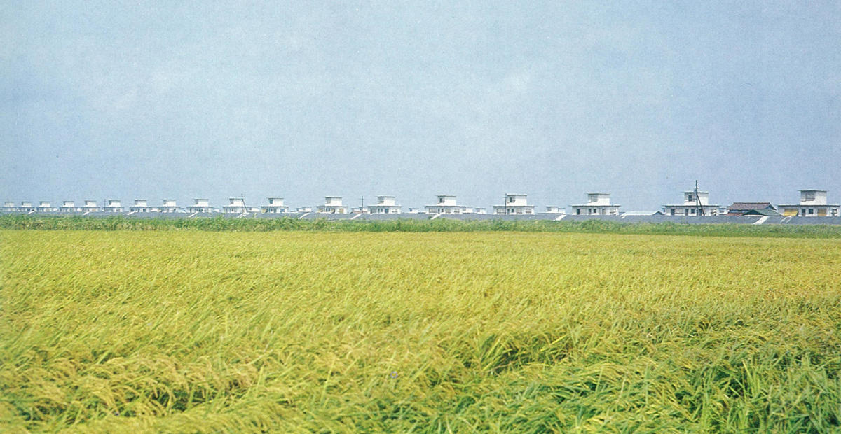 Rows of disaster restoration housing atop the Nabeta Polder dikes in the late 1960s (photo: provided by Yoshihiro Hotta)
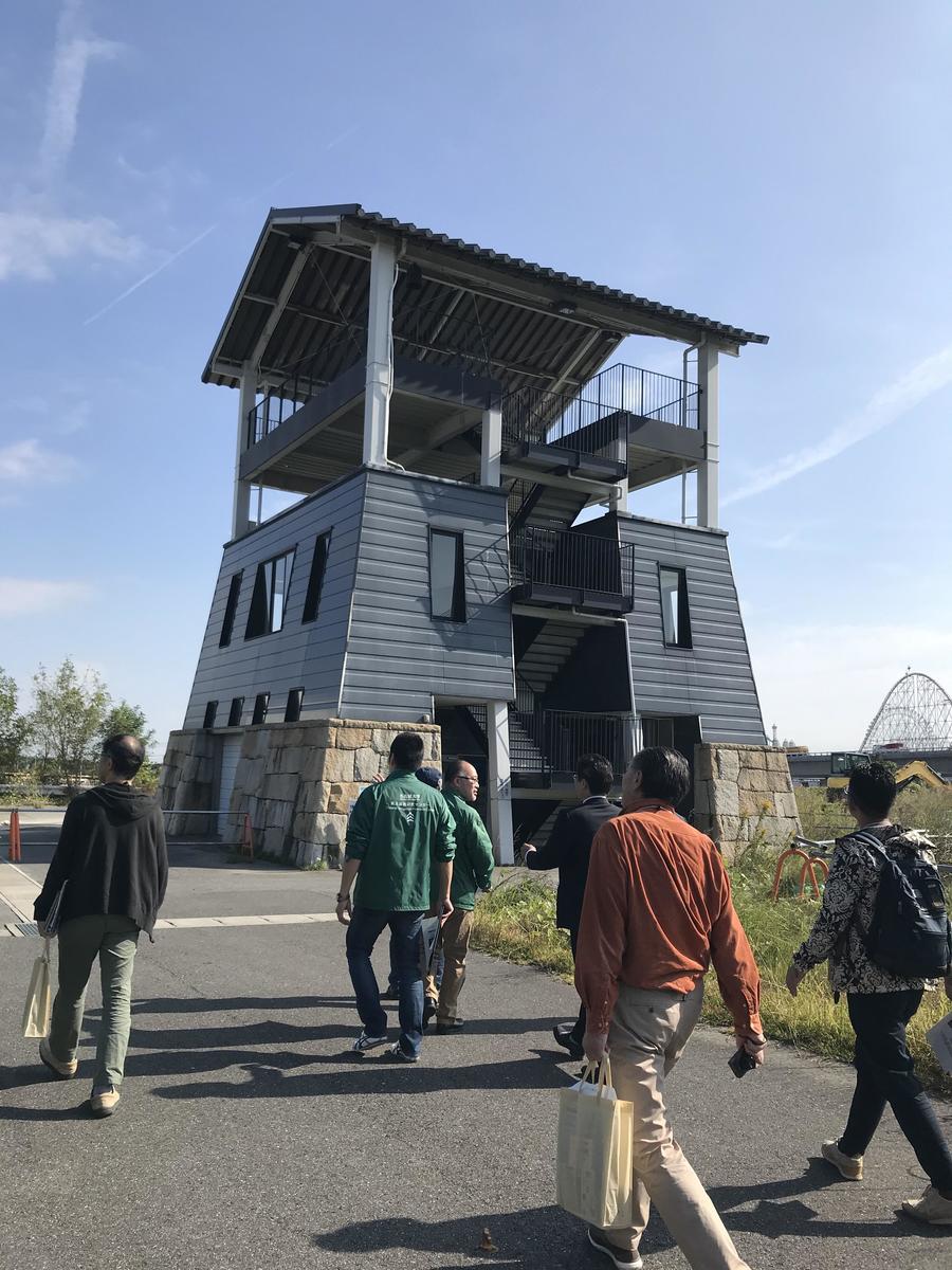
The first stop was the Nabeta Polder in Yatomi City, located at the center of the Ise Bay near the mouth of the Kiso River, which was one of the main areas affected by the storm surge. The polder had been drained in an effort to alleviate food shortages and to provide employment after World War II, and the work was more or less completed a year before the disaster. The typhoon hit the area on September 26, just as the first harvest was about to begin. The storm surge breached the dikes and wreaked havoc, washing away all 144 houses and killing 133 people - 40% of the residents.
For Yoshihiro Hotta, assistant professor at the Graduate School of Environmental Studies specializing in architectural design, the main focus of interest was the "rural restoration housing," designed by architect Chitoshi Katsuta, who was professor at the Tokyo Institute of Technology. Aiming to provide "self-built houses that were warm in winter, cool in summer, disaster-proof and beautiful, at minimal cost," he proposed a house made of stacks of 2,000 concrete blocks, designed to be built by the residents themselves. These houses were all placed together on top of high dikes rather than scattered across the polder as before. In three years, 136 houses were completed by the residents. Around 40 of these still remain.
Each house consists of a storeroom-cum-workshop on the first floor, living quarters on the second floor and a small nursery room poking out on the third floor, which could also be used as a refuge. The Nobi Plain is well known for its waju, hamlets surrounded by a ring of dikes for flood protection and featuring outbuildings called mizuya (literally "water houses"), which were placed higher than the main houses, to be used by residents to escape from floods. The third floor of the restoration housing can be described as a modern take on the mizuya; these houses were designed to be flood ready.
The design of these restoration houses is strikingly modern. Hotta explains that Katsuta knew Walter Gropius, a giant of modern architecture who founded the Bauhaus in Germany, and that his influence can be seen in the simple and functional design of these houses.
When the houses were built, they were painted green and other various colors. The idea of multi-colored clusters of modernist houses seems at odds with the image of today's temporary prefabs and restoration housing we are familiar with. "It's hard now to imagine what these buildings were like," says Hotta, "but it makes one think about how we approach post-disaster self-help and recovery."
Even though the main aim was recovery, these houses were built from the viewpoint of long-term community building, with attention also paid to the ease and comfort of day-to-day living. Hotta believes that there is a need to start taking another look at modern architecture from these angles.
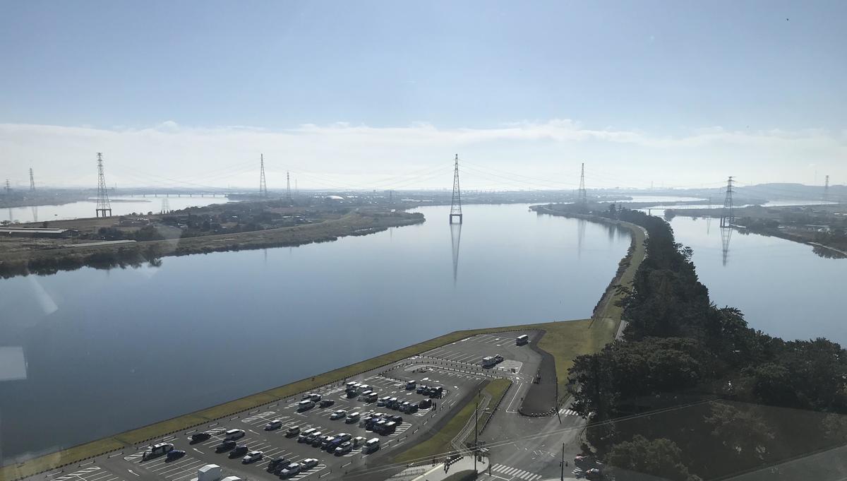 The Kiso Three Rivers viewed from the Kiso Sansen Park Center; Senbon Matsubara, created in the Horeki Chisui river improvement works, separates the Nagara (center) and Ibi (right) Rivers. The Kiso River can be seen on the left.
The Nobi Plain, which was inundated by extensive river floods caused by the Isewan Typhoon, had been formed by the sediment deposited by the Kiso, Nagara and Ibi Rivers, which are collectively known as Kiso Sansen or the Kiso Three Rivers. The fertile plain slopes towards the Yoro Mountains to the west, causing the three rivers to flow towards the western side of the plain in the lower reaches and converge in a complex crisscross pattern, making the area highly prone to flooding. Land reclamation works that started in the Edo era further expanded the plain, creating the largest tract of sub-sea level lands in Japan. The area's history is that of struggle against floodwaters; the construction of waju ring-dikes and the major water engineering works to separate the lower reaches of the three rivers, which tended to converge and cause massive floods, were all part of this perpetual battle.
The tour visited remnants of waju ring-dikes and places associated with the river separation project. At the Tagi Waju in the town of Yoro, a monument commemorates two floods; a month before the Isewan Typhoon came, the area had been hit by torrential rains, which caused the nearby Makita River to breach its dikes at the same location. The monuments states that the water reached 4.65 meters in the first flood and 3.93 meters in the second. The first deluge swallowed up 1,700 houses and took a whole month to subside, only for the area to be inundated again when the Isewan Typhoon came. Amazingly, these floods, the worst in the area's history, claimed only one life, taken by the Typhoon Isewan. Tashiro attributes this to the certain level of protection offered by the ring dikes as well as the preparedness of the community against water-related hazards, with emergency stocks kept in mizuya in the knowledge that floods were bound to come.
Tashiro and Hotta had visited these tour stops individually before, but as they went there together on reconnaissance visits, they say that their perspectives began to change. The two are now planning an exciting new research project, which they hope will shed new light on waju -from Hotta's viewpoint of an architect who designs townscapes for day-to-day living and Tashiro's from the angle of civil engineering with a particular expertise in water-related emergencies. "Perhaps we learned from this event more than anyone else," says Tashiro.
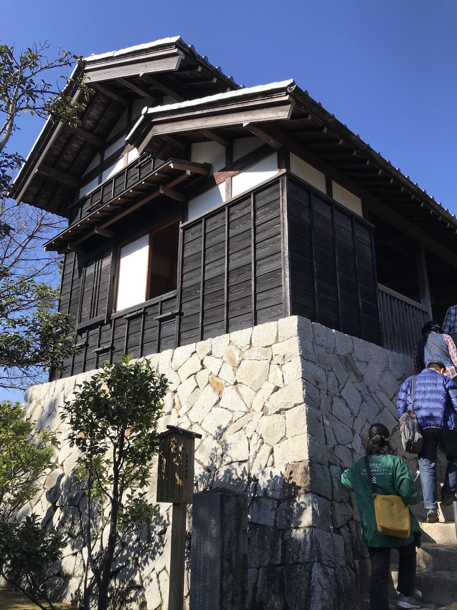 A mizuya of a waju farmhouse reproduced on the grounds of the Kiso Sansen Park Center. The sturdily constructed outbuilding was placed on a high ground.
An important collection of historical documents highlights this region's relationship with water: the Takagi-ke Monjo, which is kept in the Nagoya University Library. It was designated as a nationally Important Cultural Property last year, the first such designation for Meidai. The House of Takagi was a hatamoto - a vassal of the Tokugawa Shogunate -headquartered in the County of Ishizu in the Mino Province (today's Kamiishizu in Ogaki City) and was responsible, by order of the shogunate government, for the water management of the Kiso Three Rivers and their basins. The collection consists of some 100,000 documents and drawings dating from the Edo and the early Meiji periods and is first class both in quality and volume. Particularly important among them are over 14,000 documents on water management, which are highly rare and of national significance.
When these documents faced the threat of dispersion and loss in the post-WWII upheaval, a concerned intermediary arranged for Meidai to take custody of them for safekeeping, which the university accepted. Meidai embarked on a university-wide project to catalogue the collection and, since the start of this century, has been turning the documents into digital images for public access.
Professor Masanori Akiyama of Gifu Shotoku Gakuen University, a historian, has been researching the history of water management in the three rivers' basin at the Nagoya University Library for many years, drawing mainly on the Takagi-ke Monjo. He was invited to a special symposium held at the end of December, the last of the commemoratory series of events, and gave a talk on the history of water management in the drainage basin of the Kiso Three Rivers. The talk's focus was on the historical background of the Nobi Plain, which was devastated by the Isewan Typhoon; it described how the idea of separating the lower reaches of the three confluent, flood-prone rivers as a disaster mitigation measure came about, and explained how the complex and conflicting interests of the areas affected by the works had to be negotiated. The rich depository of drawings and documents enabled him to bring to life the history of a region faced with the challenge of living with natural disasters.
When the 2019 Typhoon Number 19 caused the Chikuma River to flood, it was reported that the local lore about a major flood called Inu no Mansui (Inundation of the Year of the Dog), which occurred in 1742, helped people escape to safety. 1742 was also the year when a plea was lodged for the project to separate the Kiso Three Rivers to take place, but the shogunate government rejected it in order to prioritize recovery efforts in central Japan following Inu no Mansui. It took until 1754 for the government to embark on the Kiso Three Rivers improvement work, known as Horeki era Chisui, and the Satsuma Domain (modern-day Kagoshima) was ordered to take on the task.
The Horeki works proved to be very difficult, and the problem was compounded by the government's bullying of the Satsuma Domain. The works were completed with the sacrifice of many Satsuma men's lives, and it is said that Hirata Yukie, the chief supervisor of the works, killed himself by committing seppuku to take responsibility for the disastrous outcome. He is now revered as an honorable hero of the Satsuma Domain. Akiyama, however, cautions about the credibility of this story, pointing out that it is not backed by any historical evidence, and the "shogunate versus Satsuma" framework of the story is problematic. In fact, according to Akiyama, these stories only started circulating in the Meiji era, when a movement to recognize and honor heroes of Satsuma gained momentum with the involvement of influential locals and former activists of the People's Rights Movement. These days, scholars agree that documented evidence suggests that Hirata probably died from illness.
Nevertheless, Hirata continues to be praised for his achievements in the local Gifu prefecture and in his birthplace of Kagoshima prefecture, and has been immortalized as the protagonist of Sonoko Sugimoto's Naoki Award-winning novel Koshu no Kishi. It is true to say that this novel was instrumental in putting the Horeki Chisui works in popular consciousness.
In his talk, Akiyama emphasized the importance of understanding the past on the basis of documentary evidence, not subjective interpretations or stories, and stressed the need to conserve historical records in order to pass on the local culture of disaster resilience to future generations so that it can be further developed and made anew.
 The monument commemorating the victims of the Isewan Typhoon in Yatomi depicts contrasting figures of a mother clutching her saved child and a father who lost his son.
The Isewan Typhoon hit the vulnerabilities of the Nobi Plain, an area with a history of water-related disasters, and the city of Nagoya, a rapidly urbanizing powerhouse of post-war economic boom. In order to prepare for the future, we must first look back on our past to understand what happened, how it happened and how the area recovered from the devastation.
In my next column, I would like to showcase some of the unique initiatives Meidai is working on as it looks to the future.